Tag Archives: trip

Destination/Trip: From Buffalo to the Almanzo Wilder Homestead

One of the destinations we want to go to with the bus is the Almanzo Wilder Homestead,  in Malone, NY.  On first glance, you might be asking ‘who’ and ‘why’, but this is the farm that Laura Ingalls Wilder’s (of the Little House books) husband grew up on before moving west and meeting her.

Now, not only is that a neat destination, but the trip there should be lots of fun.  Starting from Buffalo, our first likely stop is up on the Tonawanda Indian Reservation to top up our fuel for the trip.  While this seems like it would take us out of our way to Malone, it puts us right by the start of the ‘Cobblestone Trail’.

Located along historic Ridge Road (NY 104), the route follows the dry areas of the geography of one of the terraces of the Niagara Escarpment, just north of the route of the Erie Canal.  Used by pioneers and homesteaders in the 18th & 19th centuries, it was the major ‘northern’ route into Western New York.

These buildings, often built using skills of masons who had been brought in to work on the building of the stone aspects of the Erie Canal, were expensive and durable, being made of cobbles left from the retreat of the most recent ice age’s glaciers.  They functioned not just as houses, churches, or workshops, but also as status symbols for the communities they were in.   Now, there’s a Museum for the Cobblestone Society comprised of three cobblestone buildings and four more 19th century wooden structures (at 14389 Ridge Road in Albion).

Farther along, north of Rochester, NY Route 104 crosses the mouth of Irondequoit Bay on a long, elevated bridge that gives a great view of both the Bay and out to Lake Ontario to the north.

Following along NY 104 to the east, just past Sodus Bay, is Chimney Bluffs State Park.  Another remnant of the glacial actions of the last ice age, the eroding glacial till is constantly changing, like the Badlands of South Dakota.   These formations continue to the east along Lake Ontario to Oswego.

Following NY 104 along that route, past Oswego, 104B heads northeast to Route 3, which heads north along the eastern shore of Lake Ontario to Henderson Bay, and just past Sacketts Bay, heading north on County Road 180 to 12E, which will take us up to Cape Vincent, where Lake Ontario flows out into the St. Lawrence River and through the Thousand Islands.  NY Route 12 ends at Morristown, but the route along the river continues as NY Route 37, and continues that way until Massena.  After Massena, the road turns south-east toward Malone.

Just ten miles short of Malone (and twelve miles from the Almanzo Wilder Homestead) is the Babbling Brook RV Park.  This looks like a great base to travel from to the Homestead.  There are only 57 sites, but a quick search for reviews comes up nicely positive, so we’re looking forward to trying them out!

Finally we can get to the Homestead itself.  The museum/home-stead consists of 84 acres of farmland, woods, restored original post and beam constructed farmhouse (1840-1843), reconstructed post and beam framed barns and outbuildings, a museum/visitor center/research library/ archives/gift shop complex, orchard, covered picnic pavilion, and nature trail to the Wilder family frontage on the Trout River.

We really think that this looks like a full day’s worth of exploration, so we’ll likely have another night at the RV Park, then head home.  While the scenic route could take us 8 or so hours (without extended stops!), the route back to Buffalo, via I-81 and I-90 could take us as little as 4 and a half.  But of course, there’s more to do on the way back if we go in a round-about fashion.  But that’s another post’s work.

And if you want to know more about Almanzo Wilder, or what the homestead was like when he was a boy, check out the book!


Destination: Great Smokey Mountains National Park and The Southern Museum of Civil War and Locomotive History

NPSGreat Smokey Mountains National Park

So, yet another National Park destination, and this one is not only in the Appalachian Mountain Range, but also is at the south-western end of the Blue Ridge Mountains.  But instead of being in Virginia, here we’re located in North Carolina and Tennessee, with more wilderness in the park.

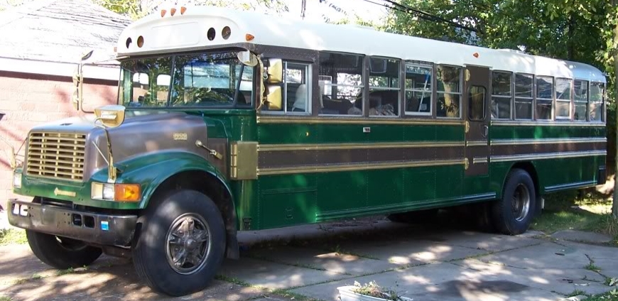
Cades Cove (Elev 1807), Elkmont (Elev 2150), and Smokemont (Elev 2198) are the only campgrounds that can accommodate an RV as long as our 35′ bus, but there are others that can fit smaller campers and RVs.   All of these are “frontcountry” campgrounds located around the edges of the park, with trails leading in farther.  But even with these edge locations, there are no showers or electrical or water hookups in the park (except for a few 5 amp sites for those with medical needs).  All the sites farther into the park are hike-in “backcountry” sites.

The 360 observation tower atop Clingman's Dome, on a nice, clear day.
The 360 observation tower atop Clingman’s Dome, on a nice, clear day.

One of the places I want to hit here is Clingman’s Dome,  which at 6643 feet, is the highest point in Tennessee and the third highest mountain east of the Mississippi.  There is a seasonal road to get up there, but the Appalachian Trail crosses over Clingman’s Dome as well.

The night sky at Clingman's Dome.
The night sky at Clingman’s Dome.

There is a 45 foot observation tower to make sure that you get a chance to see as far as you can (on some days over 100 miles).  Just seven miles from the Newfound Gap Road (Route 441) (Newfound Gap is the lowest altitude drivable pass through the Great Smokey Mountains) that traverses the park from south-east to north-west.   Just along this road to the south-east is the Smokemont campground and the start of the scenic Blue Ridge Parkway that runs from there to Charlottesville, VA (Right up along by the Shenandoah National Park).

The 'Tree of Shame' at Deal's Gap motorcycle resort.
The ‘Tree of Shame’ at Deal’s Gap motorcycle resort.

On the western end of the Park is the (infamous) ‘Tail of the Dragon’ road (Route 115) from Chilhowe, TN to Cheoah Dam, NC.  This section of road has been seen as a ‘proving ground’ for motorcyclists and sports car drivers as it borders the Park and has thus stayed undeveloped.  This 11 mile section of roadway has nearly 320 curves to it, and even with the reduction of the speed limit from 55 to 30 miles per hour, there are numerous accidents, commemorated at the ‘Tree of Shame’ at Deal’s Gap Motorcycle Resort, decorated with bits of wrecks.

So lots of scenic drives and hikes through the area, but just over 100 miles to the south is the:


The Southern Museum of Civil War and Locomotive History
The General
The General

An affiliate of the Smithsonian Institution, The Southern Museum of Civil War and Locomotive History of Kennesaw, GA, houses The General, a famous locomotive stolen by Union spies during the Civil War who tried to run it to Chatanooga, TN, a story that inspired Buster Keaton’s 1926 silent movie The General.  And while much of the museum is apparently built around preserving the historic locomotive, it also focuses on how important the supplies and mobility provided by railroad networks were for both sides during the Civil War.  They even have an machineworks exhibit that details the process of building a locomotive, from casting to assembly.


And, because it’s available, here is the full-length comedy classic:

A Week in the Bus (Allegany State Park trip – Part Ia)

I had mentioned in my first post about our trip to the Red House area of Allegany State Park that we had encountered Gerald Kirk, the man who has a nearly 11 foot long model of the  U.S.S. Boston (CAG-I), and how I’d post pictures.  I just remembered, so here are some!

Gerald Kirk and his model of the U.S.S. Boston (CAG-I)
Gerald Kirk shows off the controls for his model of the U.S.S. Boston (CAG-I). The gurney in the background is for loading/unloading the 11 foot long model. The multichannel controller controls lights, sounds and actions on the ship as well as steering and propulsion!
The U.S.S. Boston (CAG-I) in Red House Lake
Gerald Kirk getting ready to give us the full tour of his model of the U.S.S. Boston (CAG-I)
Men ready to undertake ship-to-ship loading by the main turrets, and the Captain's launch amidships of the U.S.S. Boston (CAG-I)
Men ready to undertake ship-to-ship loading by the main turrets, and the Captain’s launch amidships of the U.S.S. Boston (CAG-I)
Turret turning and guns lifting for range on Gerald Kirk's U.S.S. Boston (CAG-I)
Turret turning and guns lifting for range on Gerald Kirk’s U.S.S. Boston (CAG-I)
The U.S.S. Boston (CAG-I) on maneuvers.
The U.S.S. Boston (CAG-I) catching some of the last rays of the day's sun.
The U.S.S. Boston (CAG-I) catching some of the last rays of the day’s sun.
Gerald Kirk's model of the U.S.S. Boston (CAG-I) returning to harbor.
Gerald Kirk’s model of the U.S.S. Boston (CAG-I) returning to harbor.
Gerald Kirk's model of the U.S.S. Boston (CAG-I), with crew standing for presentation as the ship returns.
Gerald Kirk’s model of the U.S.S. Boston (CAG-I), with crew standing for presentation as the ship returns.
The U.S.S. Boston (CAG-I) at sea on Red House Lake.


All the rest of our Red House blog posts:

A Week in the Bus (Allegany State Park trip – Part I)
A Week in the Bus (Allegany State Park trip – Part II)
A Week in the Bus (Allegany State Park trip – Part III)